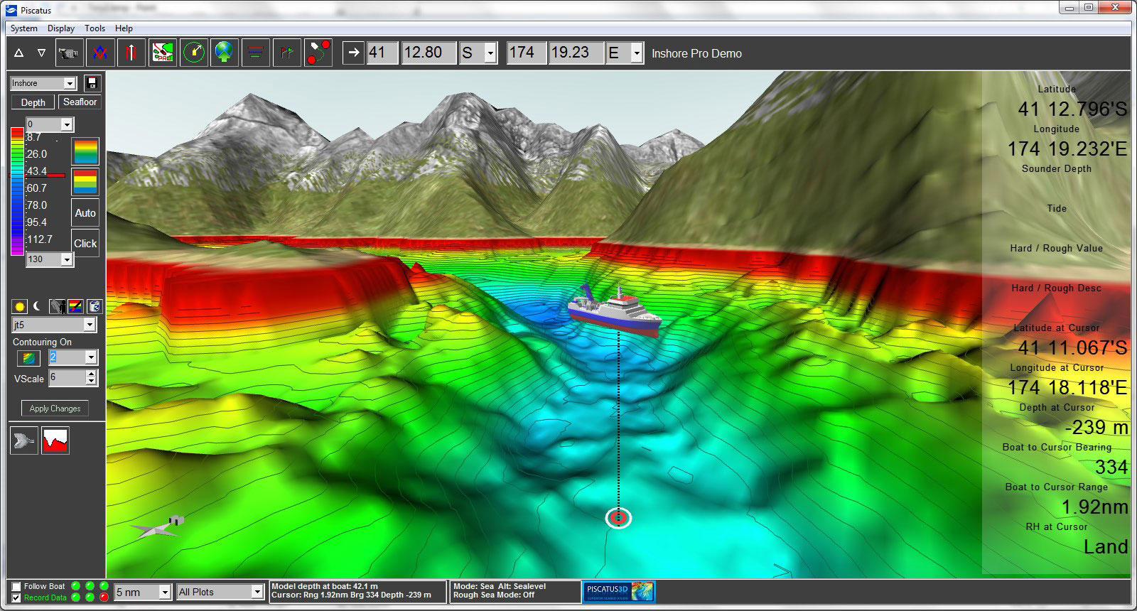
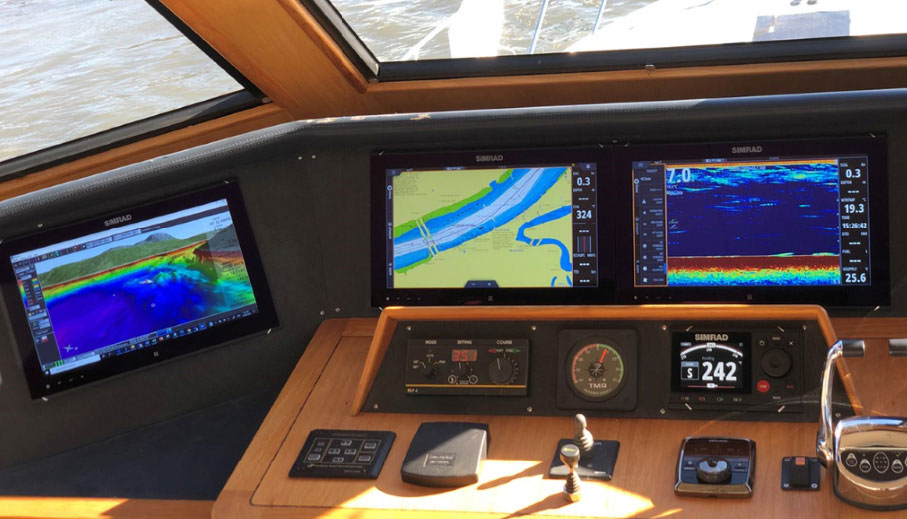
Piscatus3D delivers a real time 3D view of the ocean floor anywhere in the world, helping you to make the best decisions to catch more fish faster.
Ideal for Australia’s commercial fishing fleet, Piscatus3D is a modern and comprehensive three-dimensional (3D) fishing tool that displays in superior detail, exactly what is happening underwater in real-time as you fish. With an interface designed by fishermen for ease of use, you can view and explore underwater fishing grounds as never before.
Piscatus3D shows your boat, the seabed, surrounding land, your fishing gear as well as ARPA targets. Built on a stable and reliable technology platform, Piscatus3D automatically saves your data as you fish.
Like to try a Demo? Free trial available on the Piscatus website
Demo features:
- Real-time mapping simulation
- Trawl position simulation
- Personal settings simulation
Modes
Inshore Mode – Higher detail for shallow waters
The Inshore Mode produces the highest detail of the seafloor because of its finer data resolution and depth accuracy. For most vessels the Inshore Mode is the correct choice as it can give higher detail in shallow water and allows the user to view smaller areas. Although designed to be used in less than 1000 metres it is able to store and display data down to 3200 metres. Piscatus3D SELECT comes by default in the Inshore Mode.
DeepSea – Bigger maps for vessels operating in 1000m+ waters
Designed for the large scale operations in deeper seas, the Deepsea Mode is a more efficient system by storing less data it is able to maintain bigger map sizes in deeper water, without reducing ocean floor detail. The Deepsea Mode is recommended for vessels that work almost constantly over 1000 metres or requiring 3D maps larger than 20Nm.
Piscatus3D PRO is equipped with both Inshore and Deepsea Modes.
Add on Modules and features designed for commercial operators
Piscatus3D PRO is designed for sophisticated commercial fishing operations and is equipped with all available advanced features and modules. Piscatus3D SELECT, in its core version, is a fully functional 3D mapping system and comes with a range of pre-set and non-adjustable settings:
- 1 camera views/boat and seabed perspective (follow-boat camera only)
- 1 map size (2Nm only)
- 1 contour line frequency (2 metres)
- 1 colour pallet
- 1 vertical exaggeration setting
- 1 marker type in 1 colour
- 1 trackline colour option
- Standard Definition Display
This simple default arrangement will suit some type of fishing activities but advanced Piscatus3D SELECT users may wish to add functionality to their system by selecting one or more of the below described modules:
Customisation Module
The Customisation Module allows you to view your fishing grounds as though you are flying above the boat or following behind the trawl. This feature offers multiple camera views to visualise what you want to see, the way you want to see it. This module will also enable the following personal settings and display adjustments:
- 5 camera views/boat and seabed perspectives
- 6 map sizes
- 14 contour line settings
- unlimited colour pallet creation
- unlimited vertical exaggeration
- 5 marker types in 5 colours
- 5 trackline colour options
Whether you are trawling, netting, lining or potting, Piscatus3D unique viewing angles, marks and lines enable you to easily and accurately track your vessel’s course over the fishing grounds and to mark the location of your long-lines, nets and pots in 3D.
Trawl Net Display Module
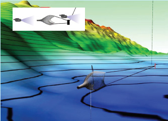
The Trawl Net Diplay Module provides your net’s position in real-time using true scale net models (select from bottom trawl, mid-water or twin-rig). Enter wire and sweep lengths, set your starboard or port offset and Piscatus3D will display the position of your trawl gear in relation to the seabed. Alternatively you can input these data directly from existing net monitoring systems such as Furuno CN22, Simrad ITI or Pacha. The Trawl Net Display module allows you to view upcoming subsurface obstacles before they become a problem. Even drive your net onto the fish!
Seabed Classification Module
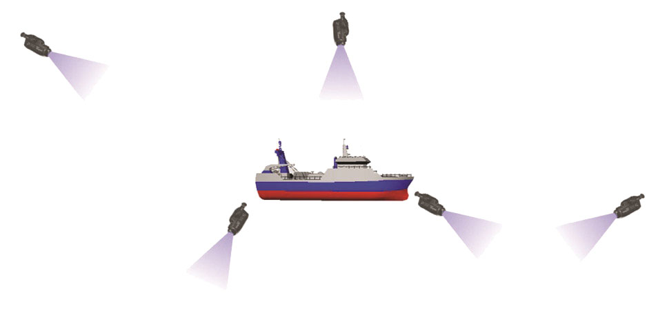
Piscatus3D can integrate with the world’s most popular seabed discrimination devices, including RoxAnn GD, SeaScan and the JRC JFC130. With these devices and Piscatus3D you can map hardness and roughness of the seabed and view in 3D areas of mud, sand, rock, weed and many other seafloor classifications.
High Definition Module
The Standard Definition 512x512 display of Piscatus3D SELECT is suitable for most fishing applications but some commercial users will definitely benefit from viewing the 3D seabed image in High Definition. The High Definition Module generates 1080x1080 display resolution and smaller details of the seabed become clearly visible. The higher the definition of the 3D image the more accurately you can place your fishing gear and target specific area.
Data-Safe Module
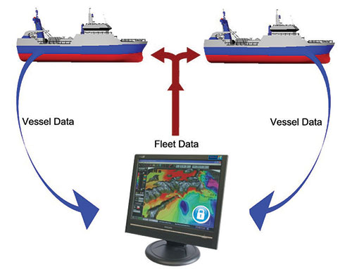
Do you have a secret fishing spot? Is protection of your data and intellectual property important to you? The Data-safe module adds extra level of security and allows you to protect your database from unauthorised access.
The Data-safe Module also enables compatibility with Piscatus3D Fleet Manager system which allows you to merge and share data from fishing grounds across an entire fleet.
DeepSea Mode Module
Piscatus3D SELECT comes by default in Inshore Mode suitable for fishing in up to 1000 meters of water. Users who occasionally or permanently fish in depths exceeding 1000 meters have the opportunity to purchase the DeepSea Mode Module, which would allow them to switch between Inshore and DeepSea modes and store data in two separate depth-specific databases.
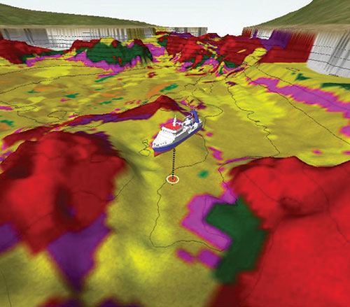
Global Bathymetry and Land data
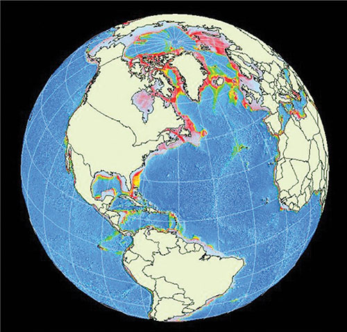
Piscatus3D PRO comes with a built in bathymetry dataset that covers the planet. This one nautical mile grid dataset is a very useful tool when fishing new areas as missing contours are predicted, so you are always working with a continuous seabed environment.
Once you start to collect real data, this built in dataset is quickly enhanced. Piscatus3D automatically filters erroneous data and any surviving glitches can be quickly identified and deleted manually.